


ABOMODELLE DER TRAX APP & WEB-APP
TraX App für sichere Flüge
in Deutschland
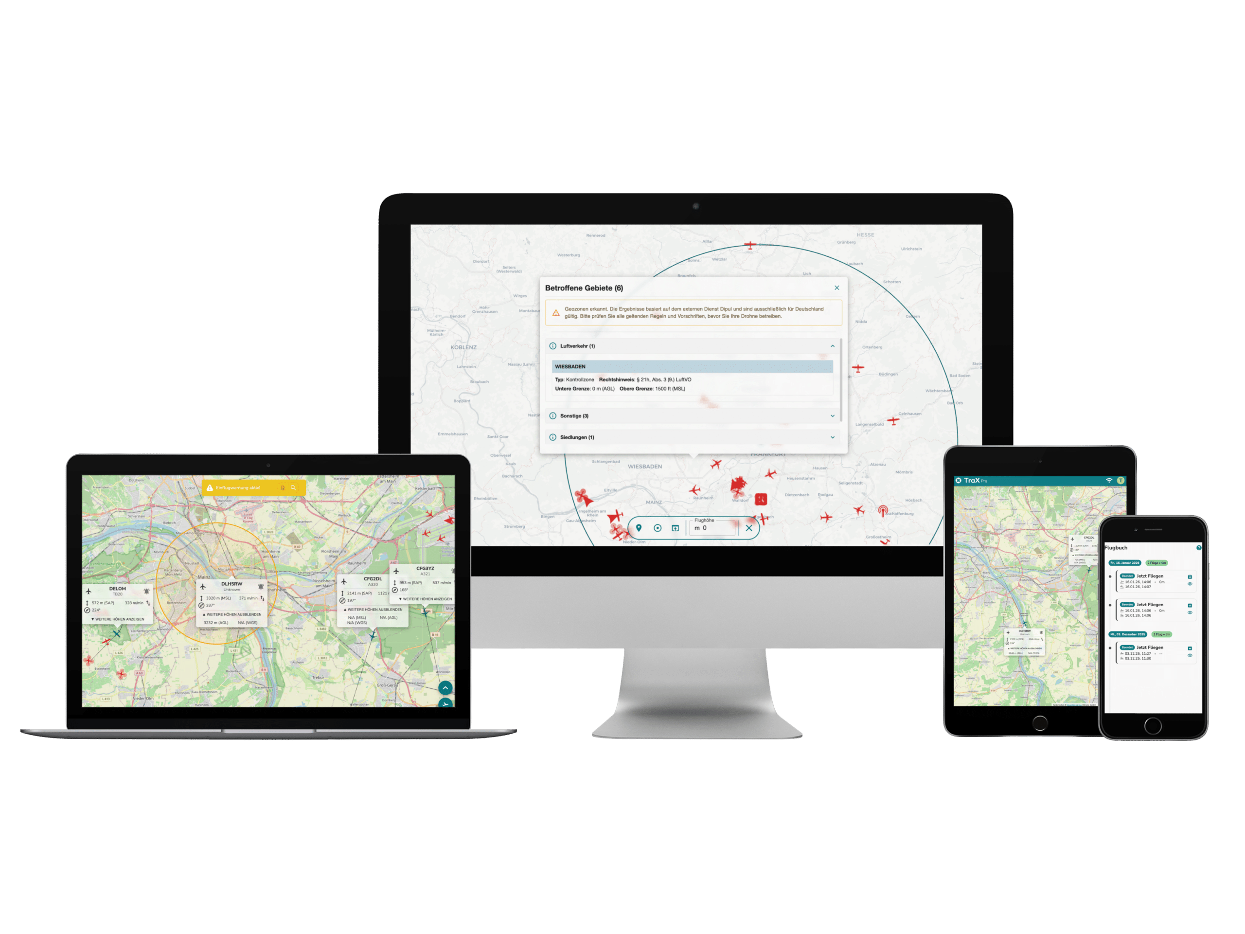
TraX ist die neue Drohnen-App von Droniq —
nutzbar als mobile App und als Web-Anwendung.
TraX prüfen Sie schnell und zuverlässig, welche Geozonen, Flugbeschränkungen, Hinweise und Luftverkehrsinformationen für Ihren Drohnenflug relevant sind. Ob Freizeitflug, gewerblicher Einsatz oder BOS-Lage: TraX unterstützt Sie bei der Planung, Validierung, Sichtbarmachung und sicheren Durchführung Ihrer Drohnenflüge.
Die kostenfreie Version TraX bietet zentrale Basisfunktionen wie Standortprüfung, Geozonenanzeige, „Jetzt fliegen“, Wetterinformationen und Flugbuch. Sie steht über den Apple App Store, den Google Play Store oder die Web-Anwendung zur Verfügung.
Für erweiterte Anforderungen stehen die kostenpflichtigen Abomodelle TraX Plus, TraX Pro und TraX Enterprise bereit. Damit erweitern Sie den Funktionsumfang unter anderem um Live-Luftlage, Warnungen, Echtzeitinformationen sowie professionelle Planungs- und Dokumentationsfunktionen. Die kostenpflichtigen Modelle können zusätzlich in der Web-App genutzt werden.
Mit Ihrem TraX Benutzerkonto können Sie sich sowohl in der mobilen App als auch in der Web-App anmelden. So nutzen Sie TraX flexibel unterwegs auf Smartphone oder Tablet und bei der Planung am Desktop im Browser.
Ob BOS-Einsatz, Industrieflug oder privater Drohnenflug – mit TraX behalten Sie den Luftraum im Blick. Sie sehen Luftlage und Flugvalidierung in Echtzeit und können Ihre Flüge ab sofort zusätzlich im TraX-Logbuch dokumentieren – alles gebündelt in einem Tool. Zudem zeigt die Web-App bemannte und unbemannte Luftfahrzeuge in Echtzeit, warnt visuell und akustisch vor Gefahren und sorgt für maximale Sicherheit bei jedem Flug.
Für Freizeitpiloten & Profis
Dank individuell konfigurierbarer Einflugwarnungen, objektbasierter Logik und Integration moderner Sensortechnologien (RADAR, ADS-B, FLARM, Remote ID) bietet TraX maximale Übersicht – direkt im Browser, ohne Installation. Mit TraX behalten Sie den Luftraum zuverlässig im Blick und erfüllen alle EASA-Vorgaben (TMPR-konform für die Risikoklasse ARC-C) – so können Sie Ihre Drohnen außerhalb der Sichtweite (BVLOS) sicher und genehmigungsfähig einsetzen.
Vier Versionen – für jeden Bedarf die passende Lösung
TraX Basic (zuküftig Plus) ist ideal für ambitionierte Freizeitpiloten und kleinere Einsatzszenarien. Alle Kernfunktionen inklusive. TraX Pro ist für professionelle Nutzer mit erhöhtem Sicherheitsbedarf – mit erweiterten Konfigurationsmöglichkeiten. TraX Enterprise ist die Lösung für Organisationen mit mehreren Nutzern und großflächigen oder dauerhaften Einsätzen. TraX (ehemals Trax Free) ist die kostenlose Backup-Version mit eingeschränkten Funktionen für alle, die wissen wollen, in welchen Geozonen sie fliegen. Ohne aktives Abonnement werden Sie auf TraX Free zurückgestuft.
Jetzt 30 Tage kostenlos testen
TraX Basic (zukünftig TraX Plus) kann 30 Tage lang unverbindlich getestet werden – ohne automatische Verlängerung. Alle anderen Modelle sind monatlich oder jährlich buchbar, jederzeit flexibel wechselbar.
Finden Sie das Passende Abo
Vergleichen Sie die TraX Modelle und finden Sie den passenden Funktionsumfang für Ihre Drohnenflüge – von der Standortprüfung bis zur Live-Luftlage, Warnungen und erweiterten Funktionen für professionelle Einsätze. TraX ist bereits als Web-App als auch im Apple App Store sowie im Google Play Store verfügbar.
Monatsplan
Jahresplan
TraX
TraX Plus
TraX Pro
TraX Enterprise
TraX

Kostenfrei
Kostenfrei
Beliebt
TraX Plus

5,99 € inkl. MwSt. / Monat
3,49 € inkl. MwSt. / Monat
TraX Pro

59,99 € inkl. MwSt. / Monat
39,98 € inkl. MwSt. / Monat
TraX Enterprise

Auf Anfrage
Auf Anfrage
NEU ab dem 11. Mai 2026
Luftraumprüfung, Wetterinfos & Flugbuch
TraX:
TraX Plus:
TraX Pro:
TraX Enterprise:
Missionsplanung & Missionscenter
TraX:
TraX Plus:
TraX Pro:
TraX Enterprise:
Live-Luftlage rund um das Fluggebiet
TraX:
TraX Plus:
20 km
TraX Pro:
60 km
TraX Enterprise:
Individuell
Einflugwarnungen im Missionsbereich
TraX:
TraX Plus:
TraX Pro:
TraX Enterprise:
Zielverfolgung für mehr Situationsbewusstsein
TraX:
TraX Plus:
TraX Pro:
TraX Enterprise:
Warnungen für ein ausgewähltes Luftfahrzeug
TraX:
TraX Plus:
TraX Pro:
TraX Enterprise:
KML-Import für die Einsatzplanung
TraX:
TraX Plus:
TraX Pro:
TraX Enterprise:
Airspace-Layer anzeigen
TraX:
TraX Plus:
TraX Pro:
TraX Enterprise:
Erweiterte Luftfahrzeug-Anzeige & Filter
TraX:
TraX Plus:
TraX Pro:
TraX Enterprise:
Erweiterte Einstellungen & Einheiten
TraX:
TraX Plus:
TraX Pro:
TraX Enterprise:
Account & Profilfunktionen
TraX:
TraX Plus:
TraX Pro:
TraX Enterprise:
TraX
TraX Plus
20 km
TraX Pro
60 km
TraX Enterprise
Individuell
Monatsplan
Jahresplan
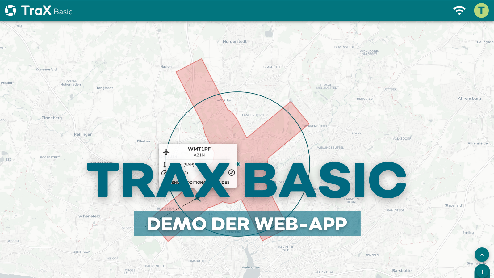
So funktioniert TraX Basic:
Auf den Produtkdetailseiten der einzelnen Abomodelle TraX Basic, TraX Pro und TraX Enterprise finden Sie weitere Video-Tutorials.
WELCHER TARIF PASST ZU MIR?
Transparent und flexibel – wählen Sie zwischen dem kostenfreien TraX Basic Testmonat (zukünftig Plus), den Monats- oder Jahresplänen von TraX Basic (Plus) oder Pro oder Ihrer individuellen Enterprise-Lösung. Für jeden Bedarf die passende Sicherheit im Luftraum.
TraX - kostenfreie Version
TraX ist die kostenfreie Version für den Einstieg. Sie eignet sich für alle, die Drohnenflüge planen, Geozonen prüfen und grundlegende Informationen zum Luftraum und Wetter abrufen möchten. Die kostenfreie Version ist über den Apple App Store und den Google Play Store oder als Web-App verfügbar.
TraX Plus - für mehr Sichtbarkeit und Live-Luftlage
TraX Plus ist ideal für alle, die Drohnenflüge aktiver überwachen möchten. Das Modell ergänzt die kostenlose Basisversion um Live-Luftlage, Warnungen und Echtzeitinformationen. So behalten Sie den Luftverkehr rund um Ihren Einsatzbereich im Blick, erhalten Hinweise bei relevanten Entwicklungen im Luftraum und können Risiken früher erkennen.
TraX Plus
30 Tage kostenlos testen
€5.99
€
0
00
inkl. MwSt. -
1 Monat gratis testen
-
Abo endet automatisch
-
Danach Downgrade auf TraX (Free)
GRATIS
TraX Plus
Monatsplan
€
5
99
inkl. MwSt., monatlich -
Laufzeit: 1 Monat
-
Abrechnung: monatlich
-
Automatische Verlängerung
-
Kündigungsfrist: 14 Tage
TraX Plus
Jahresplan
€
3
49
inkl. MwSt., monatlich -
Laufzeit: 12 Monate
-
Abrechnung: monatlich
-
Automatische Verlängerung
-
Kündigungsfrist: 4 Wochen zum Laufzeitende
TraX Pro - für professionelle Drohneneinsätze
TraX Pro richtet sich an professionelle Drohneneinsätze, Organisationen und Betreiber mit höheren Anforderungen an Planung, Überwachung und Dokumentation. Dazu gehören ein erweiterter Verkehrsradius, Einflugwarnungen für ein frei wählbares Luftfahrzeug, KML-Import für eigene Einsatzbereiche, Routen oder Planungsdaten sowie zusätzliche Karten- und Echtzeit-Overlays.
TraX Pro
Monatsplan
€
59
99
inkl. MwSt., monatlich -
Laufzeit: 1 Monat
-
Abrechnung: monatlich
-
Automatische Verlängerung
-
Kündigungsfrist: 14 Tage
TraX Pro
Jahresplan
€
39
98
inkl. MwSt., monatlich -
Laufzeit: 12 Monate
-
Abrechnung: monatlich
-
Automatische Verlängerung
-
Kündigungsfrist: 4 Wochen zum Laufzeitende
TraX Enterprise
Für Behörden, Kommunen, Infrastrukturbetreiber, Polizeien und Betreiber komplexer Drohnenflotten. TraX Enterprise eignet sich für großflächige, dauerhafte oder organisatorisch anspruchsvolle Einsätze und kann individuell auf bestehende Prozesse und Systeme abgestimmt werden.
TraX Enterprise
Jahresplan
auf
Anfrage
individuell
-
Laufzeit: 12 Monate
-
Abrechnung: monatlich
-
Automatische Verlängerung
-
Kündigungsfrist: 4 Wochen zum Laufzeitende
Häufige Fragen zur TraX App und Web-App
Allgemeine Fragen
Was ist TraX?
TraX ist die neue Drohnen-App von Droniq für Deutschland. Sie unterstützt bei Flugplanung, Standortprüfung, Anzeige relevanter Geozonen, Luftverkehrsinformationen und der Sichtbarmachung aktiver Flugbereiche. TraX ist als mobile App und — je nach Modell — auch als Web-App nutzbar.
Kann ich TraX kostenlos testen?
Ja. Die kostenfreie Version von TraX ist ausschließlich über den Apple App Store und den Google Play Store verfügbar. Sie bietet zentrale Basisfunktionen wie Standortprüfung, Geozonenanzeige, „Jetzt fliegen“, Wetterinformationen und Flugbuch. Erweiterte Funktionen stehen über die kostenpflichtigen Abomodelle TraX Plus, TraX Pro und TraX Enterprise zur Verfügung.
Kann ich mein TraX Benutzerkonto in der App und in der Web-App nutzen?
Ja. Mit Ihrem TraX Benutzerkonto können Sie sich sowohl in der mobilen App als auch in der Web-App anmelden. So nutzen Sie TraX flexibel unterwegs auf Smartphone oder Tablet und bei der Planung am Desktop im Browser.
Was passiert mit Droniq Maps?
Droniq Maps bekommt ein Upgrade und wird Mitte Mai 2026 durch TraX ersetzt. Das Update erfolgt in der Regel über den Apple App Store oder Google Play Store. Bisherige Daten aus Droniq Maps werden nicht übernommen; für TraX ist eine neue Registrierung erforderlich.
Was unterscheiden sich TraX Plus, Pro und Enterprise von der kostenfreien Version?
Die kostenfreie Version von TraX bietet zentrale Basisfunktionen für die Planung und Durchführung von Drohnenflügen, darunter Standortprüfung, Geozonenanzeige, „Jetzt fliegen“, Wetterinformationen und Flugbuch.
- TraX Plus erweitert die kostenfreie Version um Live-Luftlage, Warnungen und Echtzeitinformationen rund um den Einsatzbereich.
- TraX Pro richtet sich an professionelle Drohneneinsätze mit erweiterten Anforderungen an Planung, Überwachung und Dokumentation, etwa durch erweiterten Verkehrsradius, Einflugwarnungen, KML-Import sowie zusätzliche Karten- und Echtzeit-Overlays.
- TraX Enterprise ist für Organisationen, Unternehmen, Behörden und BOS-Einheiten konzipiert, die TraX mit mehreren Nutzern, individuellen Anforderungen oder erweiterten Workflows einsetzen möchten.
Für wen ist TraX geeignet?
TraX richtet sich an Einsatzkräfte (z. B. BOS), Unternehmen und Behörden – aber auch an ambitionierte Freizeitpiloten, die in komplexen Lufträumen sicher fliegen möchten.
Welche Versionen von TraX gibt es?
Es stehen vier Versionen zur Verfügung:
- TraX Free – als Backup für Nutzer ohne aktives Abo
- TraX Basic – für den Einstieg
- TraX Pro – für professionelle Anwendungen
- TraX Enterprise – für Organisationen mit erweitertem Bedarf
Was bietet mir TraX (Free)?
Die kostenlose Version von TraX bietet Ihnen die wichtigsten Basisfunktionen für die Planung und Durchführung von Drohnenflügen. Dazu gehören unter anderem die Standortprüfung, die Anzeige relevanter Geozonen und Flugbeschränkungen, „Jetzt fliegen“, Wetterinformationen und das Flugbuch. Für einige Funktionen ist ein Login notwendig.
Wie kann ich nach dem Testzeitraum buchen?
Innerhalb des Probemonats erhalten Sie von uns Mails, mit der Option ein Monats- oder Jahresabo abzuschließen.
Wie funktioniert die Buchung?
TraX ist als Monats- oder Jahresabo erhältlich. Sie können Ihr Modell jederzeit upgraden – flexibel und passend zu Ihrem Einsatzprofil.
Ist TraX auch mobil nutzbar?
Ja. Als vollständig browserbasierte Web-App funktioniert TraX auf allen gängigen Geräten – vom Desktop bis zum Smartphone. In Kürze ist TraX als App auch für den Apple App Store und Google Play Store verfügbar (ehemals Droniq Maps).
Wie kann ich TraX als Bookmark auf den Home-Bildschirm von Smartphones & Tablets nutzen?
Um die Web-App auf dem Home-Bildschirm nutzen zu können, müssen Sie die Web-App im Browser des Smartphones oder Tablets öffnen. Bitte beachten, dass dies nur unter folgenden Bedingungen funktioniert:
- Android, Firefox, Chrome, Edge, Opera und Samsung Internet Browser unterstützen alle die Installation von PWAs*.
- Unter iOS 16.3 und früher können PWAs* nur mit Safari installiert werden.
- Unter iOS 16.4 und später können PWAs* über das Teilen-Menü in Safari, Chrome, Edge, Firefox und Orion installiert werden.
Bei Apple-Geräten unten in der Leiste auf das Teilen-Icon klicken, dann nach unten scrollen und Wähle „Zum Home-Bildschirm“ klicken und schon haben Sie die Web-App als App auf dem mobilen Gerät.
Der Zugriff über Android erfolgt über das „Drei-Punkte-Menu“. Je nach Browser kann die Web-App über die Aktion „Zum Startbildschirm hinzufügen“ oder auch „Installieren“ zum Home-Screen als Web-App hinzugefügt werden.
* Eine PWA (Progressive Webanwendung / Progressive Web Application) ist eine Webanwendung mit Merkmalen einer nativen mobilen App.
Wie unterscheidet sich TraX von Flightradar?
Die Web-App TraX ist speziell für Drohnenpiloten entwickelt und orientiert sich an ARC-C Standard – den Qualitätsmaßstab für eine verlässliche Lagedarstellung im Drohneneinsatz.
Feature
Kann ich mit TraX prüfen, wo ich mit meiner Drohne fliegen darf?
Ja. TraX zeigt relevante Geozonen, Flugbeschränkungen und Hinweise an, damit Sie besser einschätzen können, ob ein Drohnenflug an Ihrem Standort möglich ist.
Was bedeutet „Jetzt fliegen“?
Mit „Jetzt fliegen“ machen Sie Ihren aktiven Flugbereich für andere Luftraumnutzer sichtbar. Das erhöht die Transparenz im Luftraum und unterstützt sichere Drohnenflüge.
Technik, Nutzung & Zielgruppen
Welche Systemanforderungen hat TraX?
TraX läuft direkt im Browser – es ist keine Installation notwendig. Unterstützt werden aktuelle Versionen von Chrome, Firefox, Edge und Safari. Eine stabile Internetverbindung ist erforderlich. Trax ist auch im Apple App Store und Google Play Store verfügbar.
Welche Datenquellen nutzt TraX zur Luftraumanzeige?
TraX kombiniert mehrere Technologien für maximale Sichtbarkeit: RADAR, ADS-B, FLARM und optional auch Remote ID. Damit erhalten Sie eine präzise Echtzeitdarstellung aller relevanten Luftverkehrsteilnehmer.
Ist die Nutzung von TraX in CTRs oder ED-Rs erlaubt?
TraX selbst ersetzt keine Freigaben oder Luftraumfreigaben, kann aber bei der Planung und Durchführung von Flügen in kontrollierten Lufträumen unterstützen. Die Einhaltung der geltenden Vorschriften liegt beim Piloten.
Darf ich mit TraX in allen Gebieten fliegen?
TraX zeigt Ihnen die aktuelle Verkehrslage, ersetzt aber keine Genehmigungen oder gesetzliche Pflichten. Sie sind weiterhin selbst dafür verantwortlich, geltende Luftverkehrsregeln einzuhalten.
Wird meine eigene Drohne auch in TraX angezeigt?
Wenn Ihre Drohne eine Remote ID sendet, wird sie von TraX erkannt und kann auf Wunsch durch ein Antennensystem sichtbar gemacht oder in der Warnlogik gezielt ausgeschlossen werden.
Über „Jetzt fliegen“ können Sie Ihren Flugbereich für andere Luftverkehrsteilnehmer sichtbar machen.
Wie kann ich TraX im Einsatz (z. B. BOS) einsetzen?
TraX eignet sich ideal für Lagezentren oder Einsatzleitungen. Dank Echtzeitdaten und akustischer Warnungen bleibt das Fluggeschehen transparent – auch bei mehreren Teams oder unübersichtlichen Lagen.
Ich fliege privat – lohnt sich TraX trotzdem für mich?
Ja! Auch Freizeitpiloten profitieren von TraX. Gerade in stark frequentierten Gebieten oder bei Flügen in der Nähe von Flugplätzen, Städten oder Veranstaltungen hilft TraX, den Überblick über den umliegenden Luftraum zu behalten – und frühzeitig auf bemannten Verkehr zu reagieren.
Muss ich für TraX ein Profi sein?
Nein. Die Benutzeroberfläche ist intuitiv gestaltet und auch für Einsteiger geeignet. Sie erhalten klare visuelle und akustische Warnungen – ohne komplexe Konfigurationen. Wer mehr herausholen möchte, kann die Einstellungen individuell anpassen.
Ist TraX auch für FPV-Flüge geeignet?
Absolut. Gerade bei FPV-Flügen (mit Videobrille) ist das Situationsbewusstsein eingeschränkt. TraX hilft hier, den bemannten Flugverkehr im Blick zu behalten – z. B. über ein externes Gerät oder durch eine Begleitperson im Team.
Benötige ich zusätzliche Hardware, um TraX zu nutzen?
Nein. TraX funktioniert komplett webbasiert. Sie brauchen nur ein internetfähiges Gerät (Laptop, Tablet oder Smartphone) und einen aktuellen Browser.
Ist meine Privatsphäre als Fernpilot geschützt?
Ja. TraX zeigt nur technische Daten an, die ohnehin öffentlich ausgestrahlt werden (z. B. über ADS-B oder Remote ID). Es werden keine persönlichen Daten gespeichert oder weitergegeben.