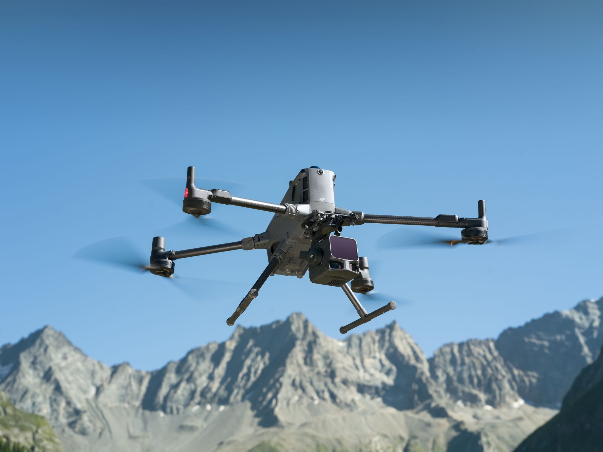
Drone accessories

New

DJI Zenmuse L3 LiDAR system

Precise aerial and long-range surveying for DJI Matrice M400

The DJI Zenmuse L3 is expected to be available from the beginning of December 2025. Pre-order the LiDAR camera system now!

The DJI Zenmuse L3 is a high-precision aerial and long-range LiDAR system developed by DJI. It combines state-of-the-art LiDAR technology with two high-resolution 100 megapixel cameras and sets new standards in precision and efficiency. It delivers razor-sharp point clouds and RGB data, is immediately ready for use thanks to the non-preheating IMU and can be seamlessly integrated into DJI Terra - for precise results with minimal effort.

12.399,16 € plus VAT.
14.755,00 € incl. VAT.
plus shipping costs
Delivery time: Expected to be available from the beginning of December. Pre-order now. Free shipping.
Do you have questions about the product? Contact form
Tel. +49 69 509 547 400 | Mail. info@droniq. de
12.399,16 € plus VAT.
14.755,00 € incl. VAT.
plus shipping costs
Delivery time: Expected to be available from the beginning of December. Pre-order now. Free shipping.
Do you have questions about the product? Contact form
Tel. +49 69 509 547 400 | Mail. info@droniq. de

Product features

Weight
1.60 kg
Dimensions
192x162x202 mm
Protection class
IP54
Operating temperature
-20°C to 50°C
Shipping weight
3.50 kg
Colors
black
Manufacturer
DJI Enterprise
CE marking

Advantages

  • High range & precision: Up to 950 m range, accuracy of 2-4 cm
  • Two 100 MP cameras & LiDAR with 16 returns: detailed point clouds and brilliant RGB data
  • Ready for immediate use: Non-preheating IMU for a quick start without waiting time
  • Efficient & powerful penetration: up to 100 km² coverage per day, precise even under vegetation
  • Seamless integration: DJI Terra & FlightHub 2 for a simple, consistent workflow
  • Versatile scan modes: linear, star or non-repeating
  • Optimized for Matrice 400: Maximum reliability and data security

Intended use

With the DJI Zenmuse L3, DJI presents the first high-precision aerial and long-range LiDAR system of its kind. The DJI Zenmuse L3 impresses in a variety of professional applications where precision, range and efficiency are crucial.

  • Large-scale mapping and digital twins
    Ideal for creating precise maps and 3D models - with a daily coverage of up to 100 km².
  • Railroad line and embankment scanning
    Enables the detailed recording and analysis of linear infrastructure such as railways, roads and embankments.
  • Forestry analyses
    Recognizes vegetation structures, tree heights and soil profiles even under dense forest cover.
  • Archaeological and geological investigations
    Visualizes fine terrain forms and hidden structures for research and documentation.
  • Emergency mapping and deployment planning
    Provides up-to-date 3D data in the shortest possible time for rapid situation assessment and coordination of emergency services.

Compatibility

Scope of delivery

  • 1x Zenmuse L3
  • 1x Zenmuse L3 Single gimbal connection
  • 1x storage case
  • 4x gimbal dampers
  • 2x CFexpress type B memory card
  • 1x CFexpress type B card reader
  • 1x DJI Matrice 400 case insert (Zenmuse L3)
  • 1x lens cleaning cloth
  • Screws and tools
  • incl. 12 months DJI Care Enterprise Plus

Technical data

System specificationDJI Zenmuse L3
System accuracy of the point cloudAt an altitude of 120 m:
Vertical accuracy: 3 cm (RMSE)
Horizontal accuracy: 4 cm (RMSE)

At an altitude of 300 m:
Vertical accuracy: 5 cm (RMSE)
Horizontal accuracy: 7.5 cm (RMSE)

Measured under the following conditions in a DJI lab environment:
1. the field contained objects with clearly recognizable edges or prominent angles. The DJI Matrice 400 was connected to a position-calibrated D-RTK 3 multifunction station. The flight route was created using the area route function of DJI Pilot 2 (with IMU calibration enabled) and linear scan mode. The airspeed was set to 15 m/s, the gimbal tilt was set to -90° and each straight segment of the flight route was shorter than 3300 m.
2. exposed, solid ground surfaces were used as checkpoints, which corresponded to the diffuse reflection model.
3) DJI Terra was used for post-processing with the "Optimize point cloud accuracy" function activated.
Point cloud thickness1.2 cm at 1σ (120 m flight altitude)
2 cm at 1σ (300 m flight altitude)

Measured in linear scan mode, using checkpoints on objects with 80 % reflectivity, without point cloud optimization or downsampling activated in DJI Terra. For a deviation of 6σ multiply the specified thickness by 6.
Combined horizontal field of view (two RGB mapping cameras)107°

Created by merging images from two cameras whose optical axes form an angle of 45° to each other.
RGB ground resolution (GSD)Average: 3 cm (300 m flight altitude)

Detailed calculation methods can be found in the user manual in the download section of the official DJI Zenmuse L3 website.
Weight1.60 kg (without single gimbal mount)

The Zenmuse L3 single gimbal mount weighs 145 g.
1.60 kg (without single gimbal mount)

The Zenmuse L3 single gimbal mount weighs 145 g.
192 × 162 × 202 mm (L × W × H)

Measured in the standard stabilized state after power-on, with a non-orthogonal gimbal design.
192 × 162 × 202 mm (L × W × H)

Measured in the standard stabilized state after power-on, with a non-orthogonal gimbal design.
64 W (typical value)
100 W (max)
Compatible aircraftDJI Matrice 400 (requires the Zenmuse L3 single gimbal connection)
Protection classIP54
Operating temperature-20 °C to 50 °C
Storage temperatureStorage temperature
LiDARDJI Zenmuse L3
Laser wavelength1535 nm
Laser beam divergence0.25 mrad (1/e²)
Size of the laser dotΦ 41 mm at 120 m (1/e²)
Φ 86 mm at 300 m (1/e²)
Detection range700 m at 10 % reflectivity, 350 kHz
950 m at 10 % reflectivity, 100 kHz
2000 m at 80 % reflectivity, 100 kHz

1. definition of range: The distance at which 50 % of the emitted laser pulses are detected. If a laser beam hits several objects, the total power of the laser transmitter is divided, which reduces the achievable range.
2. test conditions: 100 klx ambient brightness, in the central area of the field of view, with a flat object larger than the diameter of the laser beam, at a vertical angle of incidence and an atmospheric visibility range of 23 km.
3. the maximum detection range is 900 m as standard. For a longer range, please contact DJI Support or an authorized dealer.
Detection range for cables21.6 mm aluminum steel core stranded wire:
300 m at 100 klx, 350 kHz
18.4 mm black PVC insulated wire:
100 m at 100 klx, 350 kHz

1. definition of range: The distance at which a fully scanned section of wire reaches a point density of 4 points per meter.
2. test conditions: 100 klx ambient brightness, 23 km atmospheric visibility, LiDAR center looking perpendicular to the wire, non-repetitive scan mode, drone flying at 15 m/s along the wire, and the wire is clean and undamaged.
Distance accuracyAbsolute accuracy: ±10 mm
Repeatability: < 5 mm (1σ)

The above specifications can be achieved under the test conditions of 25 °C ambient temperature, 350 kHz pulse frequency, 80 % object reflectivity and at distances of 120 m and 300 m. The actual conditions may differ from those of the test environment. The results given are for reference only.
Minimum effective detection distance10 m
Frequency of the laser pulses100 kHz, recommended flight altitude < 500 m
350 kHz, recommended flight altitude < 300 m
1000 kHz, recommended flight altitude < 100 m
2000 kHz, recommended flight altitude < 50 m
Number of reflections4, 8, 16 reflections (100 kHz, 350 kHz)
4, 8 reflections (1000 kHz)
4 reflections (2000 kHz)
Cross-cycle calculation7 times
Scan mode and field of viewLinear scan mode: Horizontal 80°, vertical 3°
Star-shaped scan mode: Horizontal 80°, vertical 80°
Non-repetitive scan mode: Horizontal 80°, vertical 80°
Laser safety classClass 1 (according to IEC/EN 60825-1:2014)
RGB mapping cameraDJI Zenmuse L3
Sensor4/3 CMOS
LensEquivalent focal length: 28 mm
Field of view: 73.3° (diagonal), 62° (horizontal), 41.2° (vertical)
Aperture: f/2.0 to f/11
ClosureMechanical shutter: 2-1/1500 s (f/2.0), 2-1/2000 s (f/2.8-f/11)
Number of releases: 500,000
Electronic shutter: 2-1/16000 s
Image size100 MP: 12288×8192
25 MP: 6144×4096
Shortest recording interval
JPEG:
25 MP: 0.5 s
100 MP: 1 s

RAW or JPEG + RAW:
1,2 s
Video specificationVideo format: MP4 (MPEG-4 HEVC/H.265)
Resolution:
4K: 3840×2160 at 30 fps
FHD: 1920×1080 at 30 fps
Positioning and orientation system (POS)DJI Zenmuse L3
GNSS update rate5 Hz
POS refresh rate200 Hz
Errors in layer determinationYaw angle: 0.02° (post-processed, 1σ)
Pitch/roll angle: 0.01° (recalculated, 1σ)
Position accuracyHorizontal accuracy: 1.0 cm + 1 ppm (RTK-Fix)
Vertical accuracy: 1.5 cm + 1 ppm (RTK-Fix)
Supported PPK differential data formatsDAT: Generated in base station mode with the D-RTK 3 multifunction station and the D-RTK 2
RINEX: v2.1x, v3.0x
RTCM: v3.0, v3.1, v3.2, v3.3 (protocols: MSM3, MSM4, MSM5, MSM6, MSM7)
OEM: OEM4, OEM6

When using, ensure that the distance between the multifunction station and the aircraft does not exceed 15 km and that the multifunction station supports satellite observation with more than two GNSS constellations.
GimbalDJI Zenmuse L3
Degrees of freedom3 axles (pitch, roll, yaw)
Angular accuracy± 0,01°
Mechanical end point rangePitch: -135° to +73°
Roll: -90° to +60
Yaw: -105° to +105°

Structural limit, not the controllable turning range.
Controllable rotation rangePitch: -120° to +60°
Yaw: -80° to +80°

The roll angle is not controllable, but is only used for stabilization.
Self-testing methodRoll axle: Self-test not required
Yaw axis: Check using end stop
Pitch axis: Self-test not required
Mounting methodDetachable DJI SKYPORT (Zenmuse L3 single gimbal connection)
Data storageDJI Zenmuse L3
Storage of raw dataPhoto/IMU/Point cloud/GNSS/Calibration files
Standard memory cardCFexpress™ Type B memory card, sequential write speed 1500 MB/s
Standard card reader
Read/write speed > 900 MB/s
Software ecosystemDJI Zenmuse L3
Data acquisitionDJI Pilot 2
Data processingDJI Terra
Data applicationDJI Modify
Cloud applicationDJI FlightHub 2
Data formatDJI Terra supports the export of point cloud models in the following formats:
Standard point cloud format: PNTS/LAS/LAZ/PLY/PCD/S3MB

DJI Modify supports the import of point cloud models in the following formats:
Standard point cloud format: LAS

Information on product safety

Manufacturer:
DJI GmbH
Industriestrasse 12
97618 Niederlauer
Niederlauer, Germany
support.eu@dji.com


SZ DJI Technology Co.,Ltd
Lobby of T2, DJI Sky City, No. 53 Xianyuan Road, Xili Community, Xili Street, Nanshan District
518057 Shenzhen
Shenzhen, China
support@dji.com


Intermediaries:
Globe Flight GmbH
Borsigstrasse 7
93092 Barbing
Germany
info@globe-flight.de

Product Features

  • Performance without compromise

    An integrated 1535 nm long-range LiDAR detects objects with only 10% reflectivity from up to 950 m away. This means that the L3 delivers reliable results even under difficult conditions - with unprecedented range and precision.

  • Maximum sharpness of detail

    Two 100-megapixel RGB mapping cameras with a large field of view (107°) and mechanical shutter produce high-resolution, true-color images - perfect for precise orthophotos, DEMs and 3D models.

  • High accuracy and penetration

    A precise POS system with a heading accuracy of 0.02° and a range repeatability of 5 mm ensures results accurate to the millimeter. Thanks to the low laser beam divergence, even fine structures such as power lines or vegetation are reliably detected.

  • Efficiency in a new dimension

    In combination with the DJI Matrice 400, the Zenmuse L3 covers up to 10 km² per flight. This allows large-scale projects to be realized in record time - from planning to recording and evaluation.

  • Seamless workflow - from recording to the result

    As part of the DJI ecosystem, the Zenmuse L3 fits perfectly into the end-to-end solution consisting of DJI Pilot 2, DJI Terra and DJI Modify. Point clouds, maps and 3D models can be captured, analyzed and shared directly in the cloud - securely, quickly and efficiently.

Our competences

Full Service
Solutions

Droniq supports BOS & industry in all phases of drone operations.

Real
Experts

More than 100 years of know-how in aviation & telecommunications.

Experienced
industry professionals

Specialized in BOS and industrial drones.

Quality
seal

Droniq is a certified drone dealer.

Questions about the product?

Fill out the form. We will call you back or contact you by email.

"*" indicates required fields

Droniq training employees with a drone
Contact
Nicolas Koch

GET ADVICE FROM
OUR DRONE
EXPERTS

Invitation to the next free DRONIQlive

The A2 remote pilot certificate is essential for many drone missions - but what do you really need it for? And what happens when your certificate expires at the end of 2025?

In the next DRONIQlive, we will provide a compact overview of the requirements, application scenarios and extension of the A2 certificate.