


The drone for the professional workplace
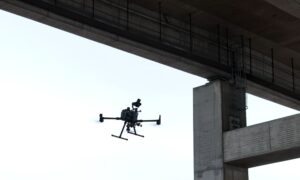
The DJI Matrice 4T (M4T) is a powerful enterprise drone that meets a wide range of requirements in industry, public safety and agriculture. Its special feature: It combines high-resolution zoom optics with a radiometric thermal imaging camera and simultaneously enables autonomous flight routines via DJI Dock 3, making it one of the most flexible and robust platforms on the market.
In this article, we show where the strengths of the Matrice 4T really pay off - and why it is a real game changer for many areas of application.
Technical highlights - what sets the M4T apart
The Matrice 4T has numerous professional functions that clearly set it apart from other systems. Particularly noteworthy is the dual camera system, which combines a 48 megapixel zoom camera with 16x optical zoom with a powerful thermal imaging camera (640 × 512 px, 30 Hz). Paired with a standard RTK module for centimeter-accurate positioning, a flight time of up to 47 minutes and a weatherproof design (IP55), it is equipped for almost all conditions - even at temperatures between -20 °C and +50 °C.
Another highlight: The Matrice 4T is fully compatible with the DJI Dock 3, allowing it to take off, land and charge completely autonomously, making it ideal for 24/7 operation - for example for routine infrastructure inspections.
Typical fields of application: Where the M4T particularly shines
Inspection of electricity, gas and industrial systems
With its high zoom resolution, the Matrice 4T enables detailed visual inspections of high-voltage pylons, substations or industrial plants - without the need for scaffolding or on-site personnel. The thermal camera helps to detect heat leaks, insulation problems or overheating at an early stage, which can prevent expensive breakdowns. It is also a valuable tool for the oil and gas industry: leaks or structural damage can be detected quickly and documented with georeferencing.
Infrastructure, construction & monument protection
Whether it's the course of tracks, bridges or large construction sites - precise 3D models and maps can be created with RTK-supported georeferencing. In the case of historical buildings, zoom optics enable sensitive facades or sculptures to be recorded from a safe distance. Thermal imaging technology, on the other hand, helps to make damage such as moisture ingress or insufficient insulation visible.
Public Safety & Rescue
The Matrice 4T also shows its strengths when supporting the police, fire department and rescue services. The thermal imaging camera detects missing persons in forests or rough terrain, even at night or in poor visibility. At the same time, the high-resolution live transmission enables precise situational awareness in real time - a decisive factor in emergency situations.
Agriculture & environmental monitoring
The Matrice 4T also provides valuable data in precision agriculture. Whether for assessing the condition of plants, monitoring irrigation or early detection of pest infestation - thermal and optical sensors help to take measures at an early stage. The M4T is also a powerful tool in the forestry sector, for example for preventing forest fires or monitoring pollutant levels.
Why the DJI Matrice 4T is superior to other systems
What sets the Matrice 4T apart is not just the combination of optics, thermography and precision navigation. Rather, it combines these features in a particularly robust, intelligent system that can be scaled for almost any application.
Dual camera system: two sensors - one flight. This allows thermal and visual data to be recorded simultaneously.
RTK support: centimeter-accurate flight routes and measurement data - ideal for mapping or construction monitoring.
Autonomous operation via DJI Dock 3: a real relief, especially for operators of large infrastructure areas. The drone flies defined routes without any manual control.
Weatherproof & secure: IP55 certification, 6-way obstacle detection, encrypted transmission - a particular advantage for BOS applications.
Seamless integration: Data can be transferred directly into existing GIS and deployment management systems.
Our conclusion on the DJI Matrice 4T
The DJI Matrice 4T impresses with its flexibility, reliability and technical excellence. Its modular design, intelligent sensor system and ability to fly autonomously make it the ideal solution for companies, authorities and organizations that rely on precise aerial data.
Whether inspection, safety, rescue or environmental monitoring - with the M4T, operations can be carried out more efficiently, safely and based on data.


