Purpose of TraX Basic
TraX Basic gives you an overview of your airspace - at all times and in real time. The innovative, platform-independent web app displays the surrounding air traffic precisely and warns you visually and acoustically of approaching aircraft. Thanks to the integration of RADAR, ADS-B and FLARM, all relevant aircraft are reliably detected. Our web app fulfills the TMPR requirements for ARC-C and enables reliable BVLOS flights in the Specific Category.
TraX is the ideal solution for:
- BOS organizations such as volunteer fire departments during operations
- Small and medium-sized enterprises (SMEs), for example for building and roof inspections in urban areas
- Recreational pilots who want to fly safely and relaxed
- Drone operations in urban and densely populated areas
- Companies that want to take their first steps towards BVLOS operation
Thanks to the digital visibility of all relevant aircraft, TraX helps you to carry out flights safely and efficiently - for smooth airspace operations.

Scope of delivery
A 30-day free single user license for the TraX Basic application for the Germany region is supplied. The trial subscription is automatically terminated after 30 days. Access to TraX is transmitted digitally to the user.
Note for ordering the free trial month: Each customer is only entitled to order the trial month once.

Feature overview of the TraX variants
Cards | TraX Free | TraX Basic | TraX Pro | TraX Enterprise |
---|---|---|---|---|
Selectable background maps for all application areas | x | x | x | x |
Geozone layer (Dipul layer) | x | x | x | x |
Airspace layer | x | x | ||
User uploads (KML) | x | x | ||
Geoserver integration (individual additional layers) | x |
Traffic & Tracking | TraX Free | TraX Basic | TraX Pro | TraX Enterprise |
---|---|---|---|---|
General air traffic | x | x | x | |
Traffic radius | 5 km | 50 km | individual | |
Automatic Identification System (marine traffic) | x | x | x | |
Location determination using various methods (GPS, address search, manual input) | x | x | x | |
Find position via GPS of the end device | x | x | x | |
Track a single aircraft | x | x | x | |
Drone Detection System | x | |||
Direct Remote ID | x | |||
Multiple monitoring zones | x |
Setting & display | TraX Free | TraX Basic | TraX Pro | TraX Enterprise |
---|---|---|---|---|
Customization of the application to user needs | x | x | x | x |
Customizable representation of air traffic | x | x | ||
Display of flight progress & flight preview | x | x | ||
Selection of height preferences | x | x | ||
Height filter | x | x |
Warnings & Alerts | TraX Free | TraX Basic | TraX Pro | TraX Enterprise |
---|---|---|---|---|
Intrusion alerting, visual & audio warnings, warning mode | x | x | x | |
Setting the size of the warning cylinder | x | x | x | |
Leave the display switched on | x | x | ||
Current position or destination as the focus of the warnings | x | x | ||
Exclude individual destinations from entry warnings | x | x |
Tools & Miscellaneous | TraX Free | TraX Basic | TraX Pro | TraX Enterprise |
---|---|---|---|---|
Measuring tool for distances | x | x | x | x |
Retrieve coordinates at a specific position | x | x | x | x |
System requirements
We recommend the following browsers/devices for using TraX Basic:
- Current PC, laptop, smartphone or tablet (at least 4 GB RAM)
- Windows 10+, macOS 11+, Android 10+, iOS 14+
- Current browser: Chrome, Firefox, Edge or Safari
- Stable Internet connection

Software features: TraX Basic

-
Traffic & tracking in real time
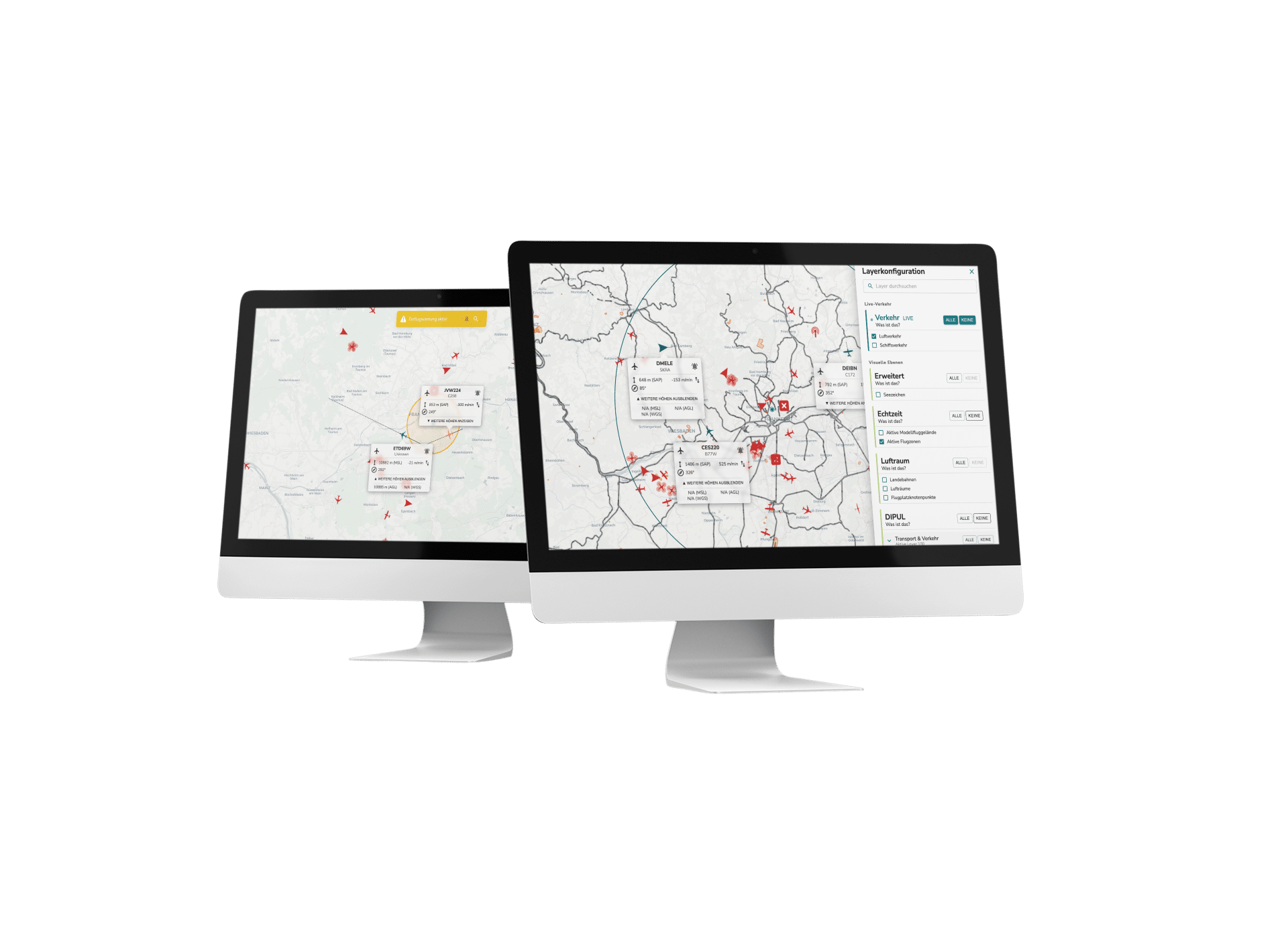
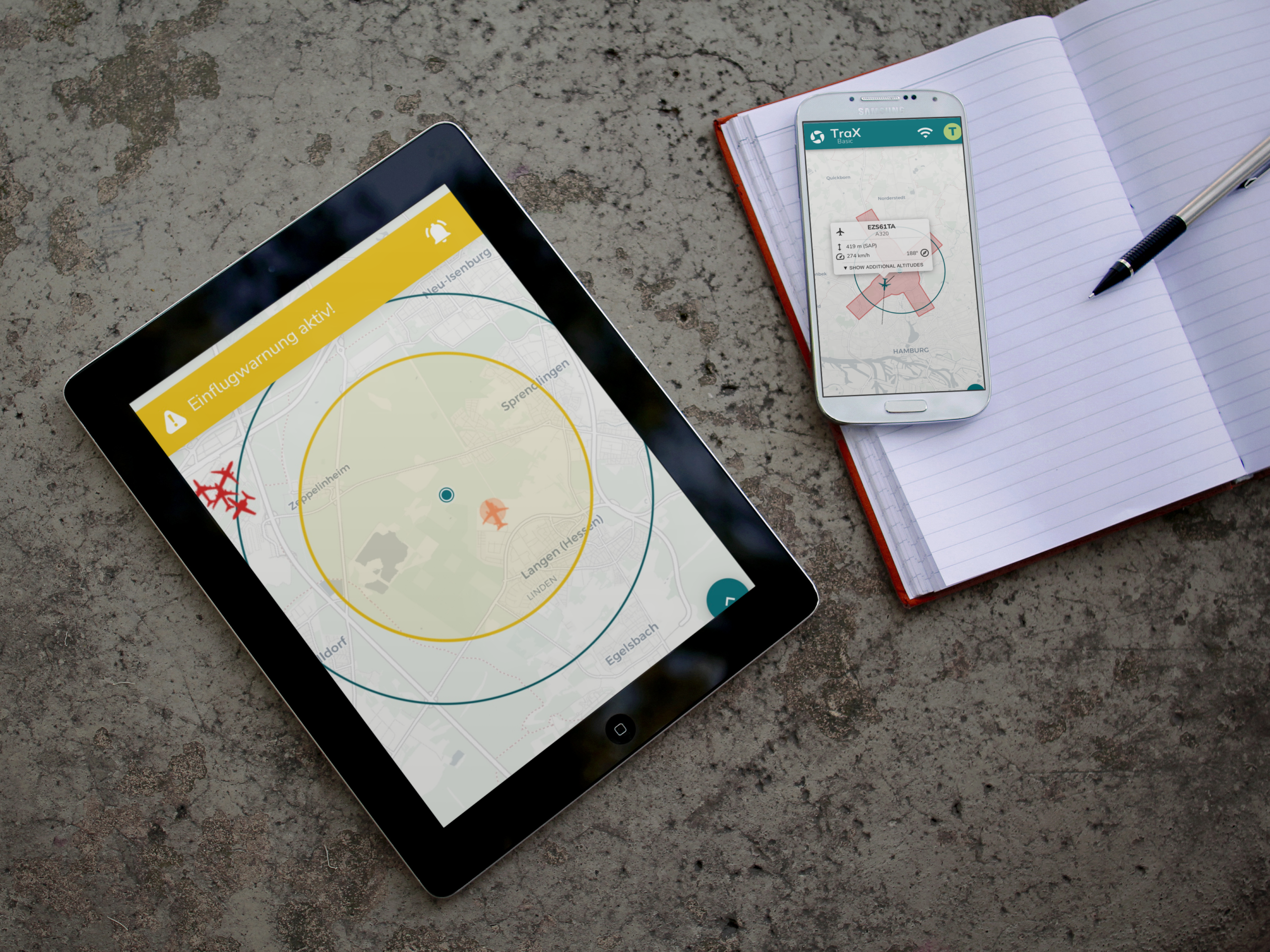
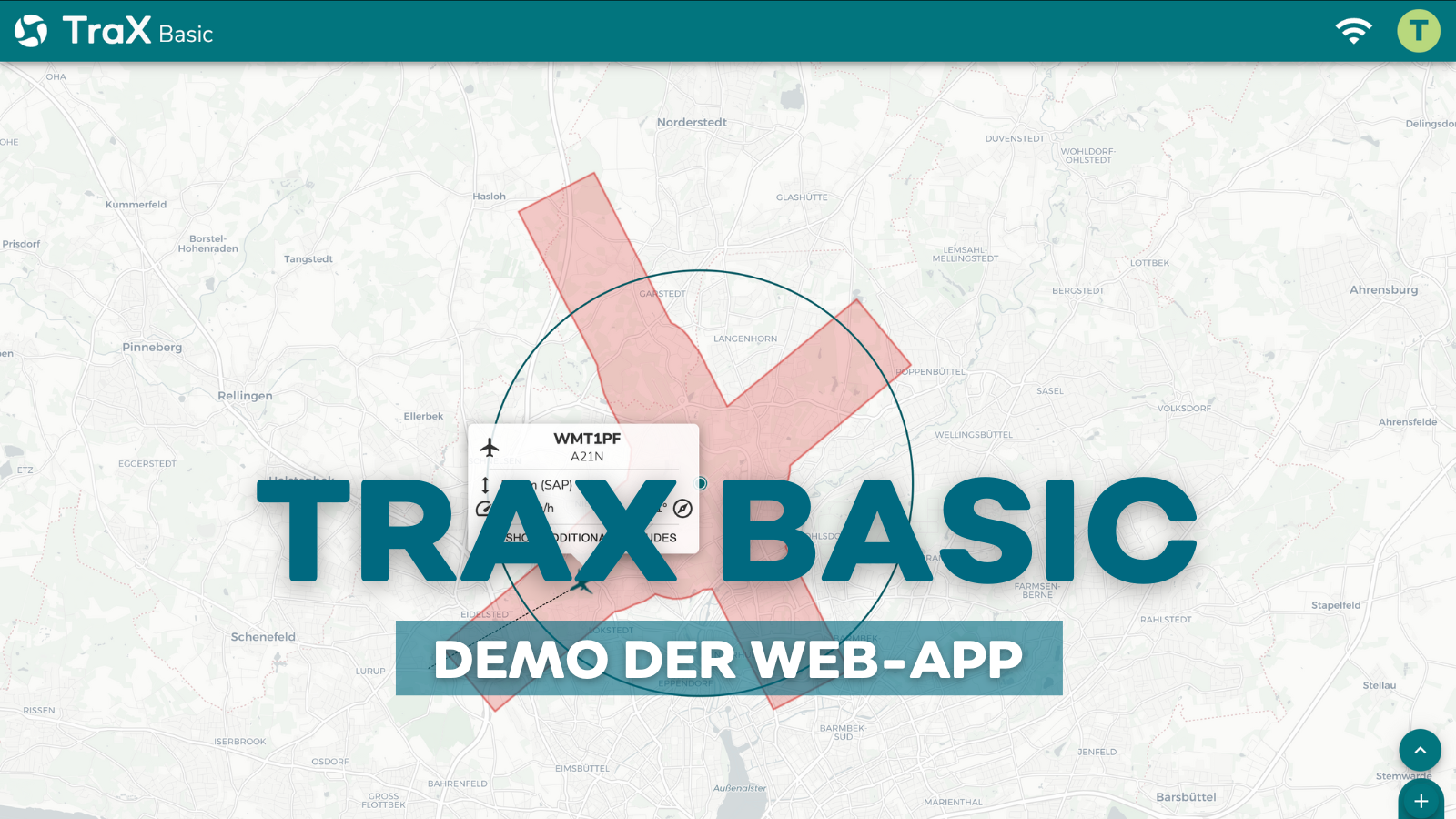
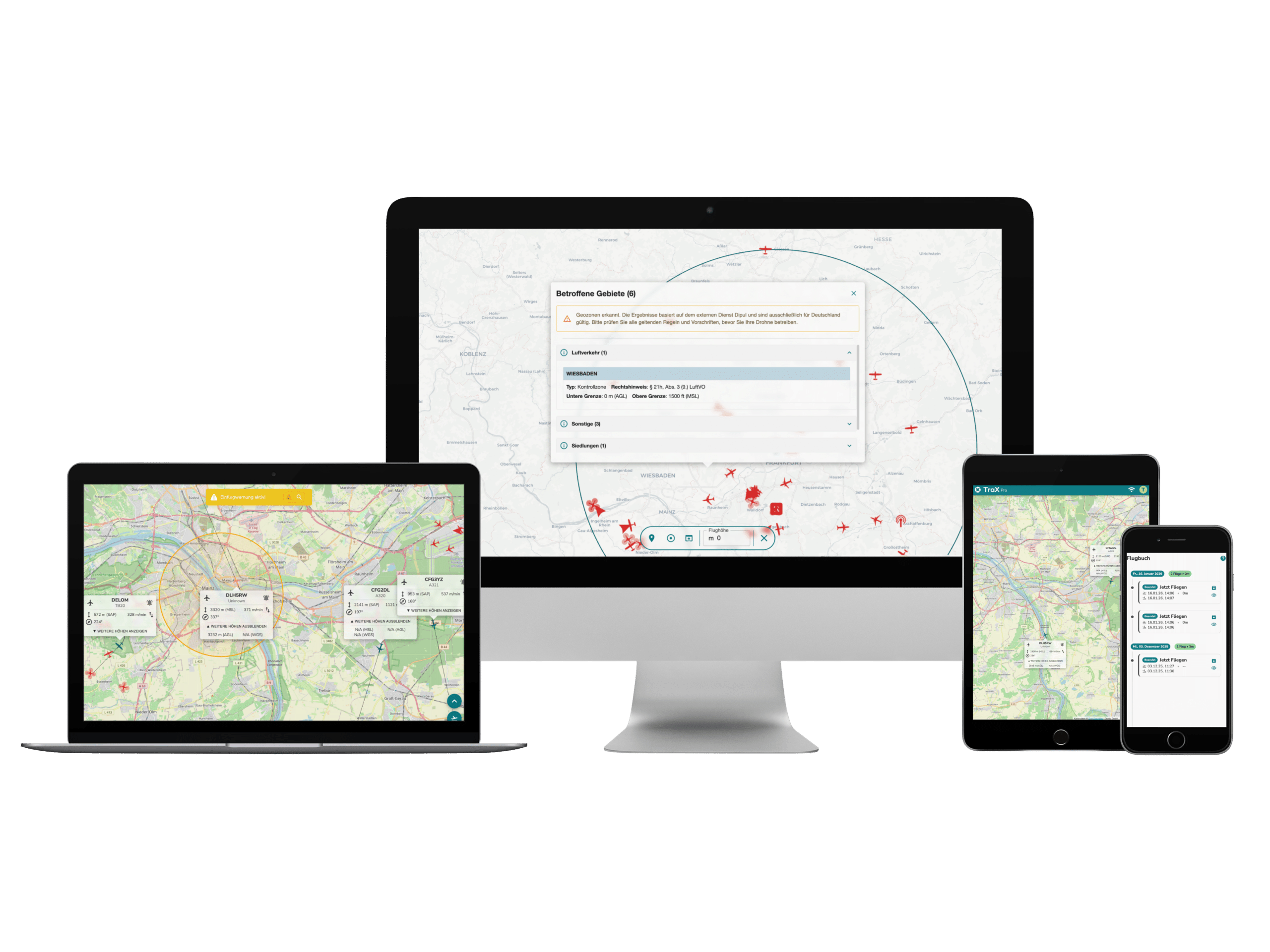
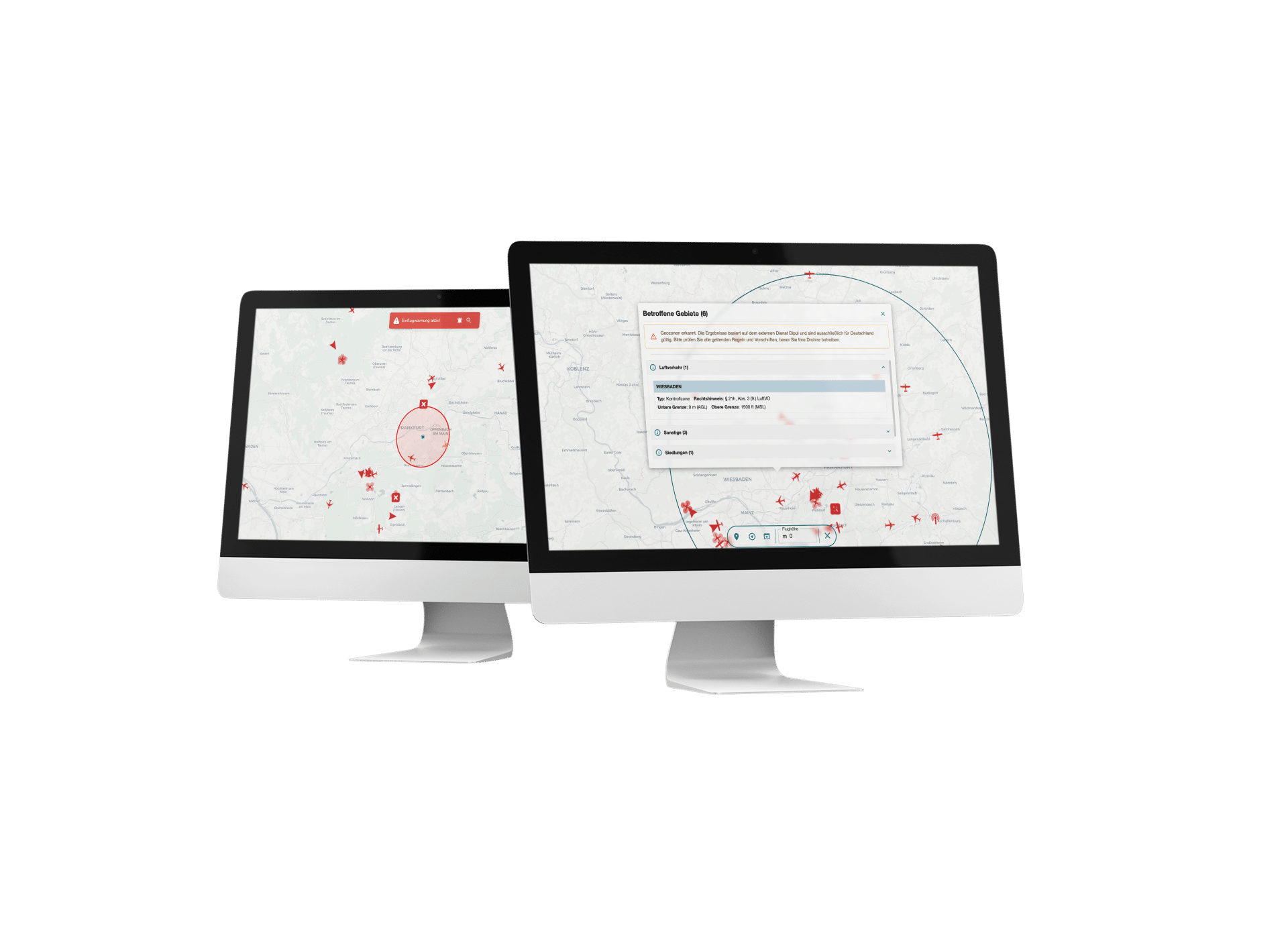
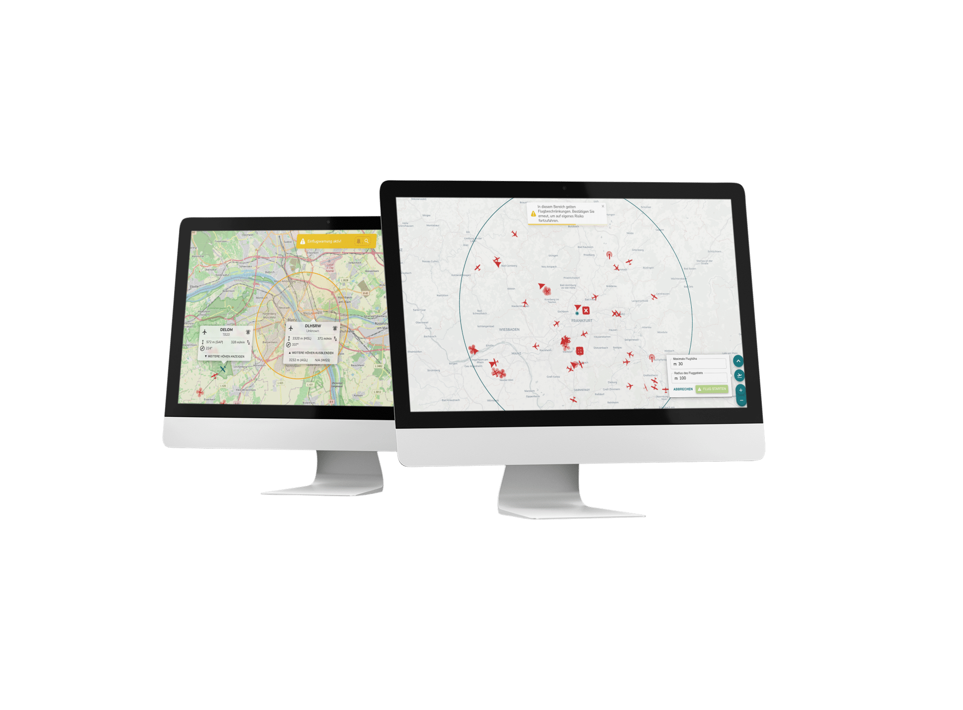
With our web app, you can keep an eye on your operational area at all times: It displays all manned and unmanned aircraft in real time and integrates live traffic, air traffic and AIS (marine traffic) directly on the map.
By combining RADAR, ADS-B, FLARM and UAS remote identification, the app ensures precise and comprehensive real-time monitoring.
The center point can be set flexibly via free-text search, GPS positioning or manual input, and individual aircraft can be tracked specifically - so you can monitor your surroundings precisely within a reception radius of 5 km.
-
BVLOS approvable
TraX fulfills the TMPR requirements for ARC-C and is therefore optimally prepared for BVLOS operations in the Specific Category. It offers maximum reliability in airspace surveillance and meets all EASA regulatory requirements - for safe, approvable operations beyond visual range.
-
Map variety for precise display
Our TraX Basic web app offers you various map views that show your area clearly and concisely.
With background maps for a detailed display, static map layers for the permanent display of important information and geo-zone layers for the simple visualization and management of zones, you always have all relevant data directly in the application, exactly where you need it.
-
Flexible & individual settings
Our web app allows you to customize the display according to your needs: Users can choose the ad units themselves and activate or deactivate advanced functions.
Thanks to the integrated language selection between German and English, operation is particularly convenient - and best of all, the app is fully optimized for mobile devices, so you can work flexibly anytime and anywhere.
-
Warnings & alerts: safety through clear signals
TraX Basic offers reliable detect-and-avoid support with both visual and acoustic warnings so that you can recognize potential dangers immediately.
The warning mode can be customized, including the option of setting the size of the warning cylinder according to your requirements. In this way, we ensure that you are informed early and effectively at all times.
-
Precise tools for your planning and analysis
Our web app provides you with practical tools with which you can measure distances precisely and easily retrieve coordinates at specific positions.
In this way, we support you in carrying out your operations and analyses even more precisely and efficiently.
This is how TraX Basic works:
Our competences
Awarded several times
Multiple awards in the areas of safety, traffic and innovation.
Practice
tested
Flown more than 12,000 km of route beyond visual line of sight (BVLOS).
Full Service
Solutions
Droniq enables efficient and safe drone operations for BOS & industry.
Real
Experts
More than 100 years of know-how in aviation & telecommunications.